Remote sensing technology has undergone a remarkable evolution over the years, from the use of satellites to the emerging trend of drones. These advancements have revolutionized the way we collect data and monitor changes in our environment with unprecedented accuracy and efficiency.
Satellites have long been the cornerstone of remote sensing technology, providing a bird’s eye view of the Earth from space. These orbiting platforms are equipped with sophisticated sensors that can capture images and data from a wide range of electromagnetic wavelengths, allowing scientists to monitor everything from weather patterns to land use changes. Satellites have enabled us to track deforestation, monitor urban expansion, and even predict natural disasters with greater precision than ever before.
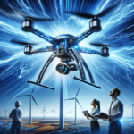
However, satellites have their limitations. They can be expensive to launch and maintain, and their coverage area is often limited by their orbit. This has given rise to the use of drones as a complementary tool in remote sensing technology. Drones, or unmanned aerial vehicles (UAVs), can quickly and easily be deployed to capture high-resolution images and data from hard-to-reach or hazardous locations. This versatility makes them an invaluable asset in numerous applications, from agriculture and forestry to disaster response and infrastructure monitoring.
One of the key advantages of drones is their ability to capture data at varying altitudes and resolutions, allowing researchers to gather detailed information on a smaller scale. This level of precision can be crucial for monitoring changes in vegetation health, water quality, and land use over time. Drones also offer greater flexibility in terms of flight paths and imaging capabilities, making them ideal for targeted data collection in specific areas of interest.
The evolution of remote sensing technology has also been driven by advancements in artificial intelligence and machine learning. These technologies have enabled us to process and analyze massive amounts of data quickly and accurately, leading to more meaningful insights and predictions. With the integration of AI, remote sensing technology has become even more powerful in its ability to monitor and respond to environmental changes in real-time.
The combination of satellites, drones, and AI has opened up new possibilities in remote sensing technology, transforming the way we study and understand our planet. Researchers are now able to track changes in ecosystems, monitor wildlife populations, and assess the impacts of human activities on the environment with unprecedented detail and precision. This wealth of information is invaluable in informing policy decisions, guiding conservation efforts, and responding to natural disasters.
As we look to the future, the evolution of remote sensing technology is likely to continue, with new innovations and advancements on the horizon. From the development of hyperspectral sensors to the use of swarms of drones for data collection, the possibilities for remote sensing are endless. This technology will play a vital role in addressing global challenges such as climate change, natural resource management, and disaster response, ensuring a more sustainable and resilient future for generations to come.